WeatherGPX, W WEATHER, W GROUP and W OBD2 come from the same maker. Each works on its own, and the three W apps also live inside WeatherGPX.
The weather forecast at every point along your route, timed to your arrival. Then live navigation on the same GPX track.
Open app Read more →Everyone in your group on one live map, from a single link. An SOS button, and voice for the whole ride through Discord.
Open app Read more →Speed, RPM, gear, coolant, battery and fault codes on your phone, through a Bluetooth adapter left on the bike.
Open app Read more →Tap anywhere on the map: now, the next hours in 15-minute steps, the day and the week. Radar, hazards, offline maps. Free, no account.
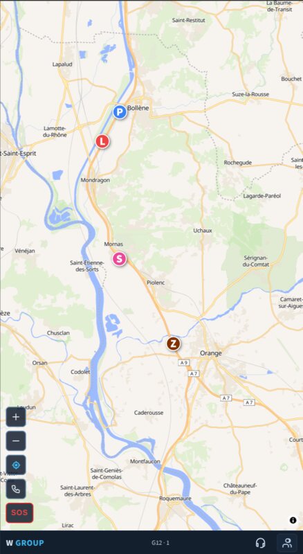
Open app Read more →One link. Everyone appears as a coloured dot moving in real time, an SOS button if something goes wrong, and voice for the whole group. No account, nothing to sign up for, free.
Works in any browser, and installs on iPhone and Android.
Coloured dots with each rider's initial, updating every few seconds, with their speed. You always know who is ahead and who is missing.
The organiser drops in a free Discord room and everyone gets a Voice button. Full duplex, no push to talk, and it works through a helmet intercom.
One button puts your name and your position in front of everyone in the group. Anyone can cancel it once things are fine. Next to it, the local emergency number for wherever you are — 235 countries, kept on the phone, so it still works with no signal.
Anyone with the link can follow the whole group on the map without sharing a position of their own. Watchers are unlimited and do not count towards the twelve.
Ride with a Garmin inReach or a SPOT? Link its share page once and, wherever the phone has no network, your dot keeps moving from the satellite feed every few minutes, marked sat. Made for the desert and the high passes.
In a browser, positions stop when the screen goes dark or another app is in front, so keep the phone mounted and on. The Android app keeps sending with the screen off. In testing on Google Play, ask on our Discord.
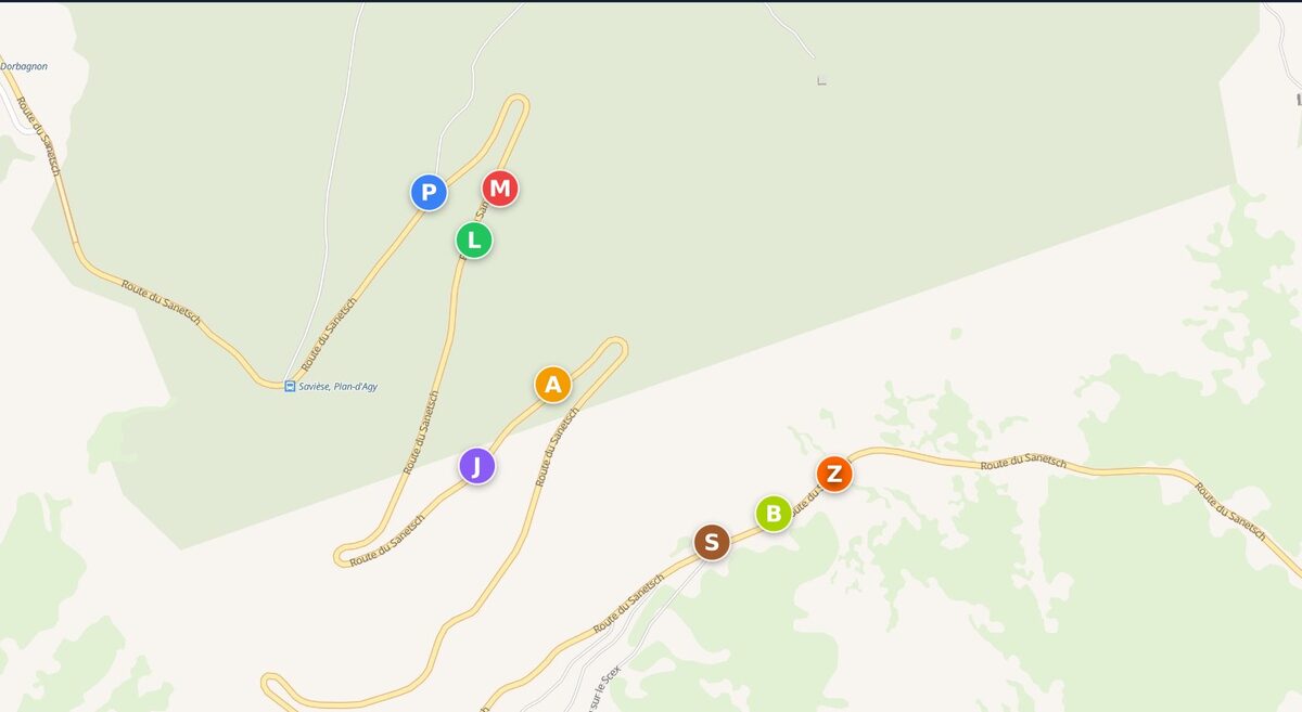
Five bikes on the Sanetsch, spread over a couple of kilometres because that is what a pass does to a group. Nobody sits in anybody's mirrors, nobody waits at every junction. The map already knows who is where, and the voice room means you say so without stopping to say it.
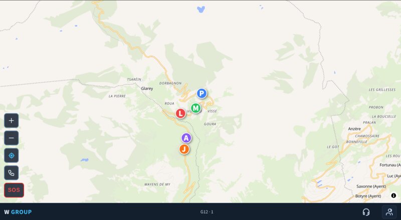
Nine of you start the pass together. Three are gone up the road, three are somewhere behind, and by the top there are kilometres between them. The map shows all of it — who is where, who has stopped. If someone goes down, the two people with her can reach the other seven.
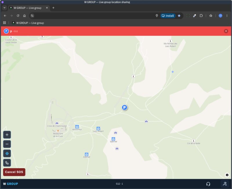
You don't need a group. A walker on an easy mountain — the kind with cows on it, not ropes — and one person at home following the dot is enough. Press SOS and it lands on that screen with the position on it. The same view scales to a club: follow several groups at once, tap a row to switch which one the map shows, and every group with a voice room carries its own microphone on that row.
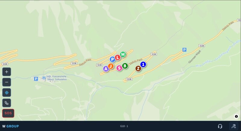
Paris to the Mediterranean, four families, nothing fancy. You can see who missed the junction, and say « we're stopping at the next services » without a round of phone calls.
Riding in a group means intercoms, and we have used all of them. Bluetooth sounds very good but the range is short. Mesh reaches further and sounds merely good, and it does not work between manufacturers.
Then there are the data apps, including the ones the intercom makers built themselves. They need a data connection like anything else, and they still sound worse than Mesh.
We ran our own voice server for a while too. It landed in the same place — no better than the intercom makers’ own apps. That is when we stopped trying to build voice ourselves.
Discord sounds far better than any of them. It runs on Opus, the codec designed for voice over the internet, with Krisp noise suppression on top, and both have had years of tuning against exactly this problem. It also comes back much faster after a tunnel.
Its one drawback is needing a data connection. Inside W GROUP that costs you nothing: without data there are no dots on the map either.
Setting voice up takes about five minutes, once: the organiser's guide. Joining takes two: the member's guide.
Do I need an account?
No. No account, no registration, no phone number, no email. Pick a name and a colour and you are riding.
What does it cost?
Nothing.
How many people?
Up to 12 sharing their position, and any number of watchers.
Can I use it on my own?
Yes. One person out and one person at home watching is a normal way to use it — create a group and send the link to that one person.
What happens to my location?
Only your latest position is kept, only to draw your dot for your group, and it is deleted when you leave or when the group expires after 24 hours. No history, no tracking, no analytics.
Does it work on iPhone?
Yes. It runs in the browser and installs from the Share menu.
Does it keep sending with the screen off?
In a browser, no. Phones stop a web page a few seconds after the screen goes dark or the app goes to the background, so keep the phone mounted with the screen on, which W GROUP does for you while you are a member. If you ride with the phone in a pocket, use the Android app: it keeps sending with the screen off. It is in testing on Google Play, ask for access on our Discord.
Does it work where there is no phone signal?
Positions need internet, so without signal your dot stops and shows the age of its last fix. If you carry a Garmin inReach or a SPOT, link its share page in the panel (Satellite tracker): the server reads the tracker's public feed and keeps your dot moving every few minutes, marked sat, while the phone is silent. The tracker's own SOS still goes to its rescue centre, not to the group; an inReach emergency or a SPOT Help message is also shown to the group.
Un seul lien. Chacun apparaît comme un point coloré qui bouge en temps réel, un bouton SOS en cas de problème, et la voix pour tout le groupe. Sans compte, sans inscription, gratuit.
Fonctionne dans tout navigateur, et s’installe sur iPhone et Android.
Des points colorés avec l'initiale de chacun, mis à jour toutes les quelques secondes, avec la vitesse. Vous savez toujours qui est devant et qui manque.
L'organisateur colle un salon Discord gratuit et tout le groupe obtient un bouton Voix. Full duplex, sans bouton à presser, et ça passe par l'intercom du casque.
Un bouton place votre nom et votre position sous les yeux de tout le groupe. N'importe qui peut l'annuler une fois la situation réglée. À côté, le numéro d’urgence local là où vous êtes — 235 pays, gardés sur le téléphone, donc disponibles même sans réseau.
Avec le lien, on peut suivre tout le groupe sur la carte sans partager sa propre position. Les observateurs sont illimités et ne comptent pas dans les douze.
Vous roulez avec un Garmin inReach ou un SPOT ? Reliez sa page de partage une fois et, partout où le téléphone n'a pas de réseau, votre point continue d'avancer grâce au flux satellite toutes les quelques minutes, marqué sat. Fait pour le désert et les hauts cols.
Dans un navigateur, les positions s'arrêtent quand l'écran s'éteint ou qu'une autre app passe devant : gardez le téléphone sur son support, allumé. L'application Android continue d'envoyer écran éteint. En test sur Google Play, demandez sur notre Discord.
Cinq motos dans le Sanetsch, étalées sur deux kilomètres parce que c'est ce qu'un col fait à un groupe. Personne ne colle aux rétroviseurs, personne n'attend à chaque intersection. La carte sait déjà qui est où, et le salon vocal fait que vous le dites sans vous arrêter pour le dire.
Vous partez à neuf dans le col. Trois sont déjà loin devant, trois quelque part derrière, et au sommet il y a des kilomètres entre eux. La carte montre tout : qui est où, qui s'est arrêté. Si quelqu'un tombe, les deux personnes avec elle peuvent joindre les sept autres.
Pas besoin d'être un groupe. Un marcheur sur une montagne à vaches — pas une course d'alpinisme — et une personne à la maison qui suit le point, cela suffit. Un appui sur SOS et il arrive sur cet écran, avec la position. La même vue tient pour un club : suivez plusieurs groupes à la fois, touchez une ligne pour choisir celui que la carte affiche, et chaque groupe qui a un salon vocal porte son propre micro sur sa ligne.
Paris—Méditerranée, quatre familles, rien d'extraordinaire. Vous voyez qui a raté la sortie, et vous dites « on s'arrête à la prochaine aire » sans faire le tour des téléphones.
Rouler en groupe, c'est rouler en intercom, et nous les avons tous utilisés. Le Bluetooth sonne très bien mais la portée est courte. Le Mesh porte plus loin et sonne seulement bien, et il ne fonctionne pas d'une marque à l'autre.
Viennent ensuite les applications qui passent par les données, y compris celles des fabricants d'intercoms eux-mêmes. Elles ont besoin d'une connexion comme les autres, et elles sonnent quand même moins bien que le Mesh.
Nous avons aussi fait tourner notre propre serveur vocal. Le résultat a été le même — pas meilleur que les applications des fabricants d’intercoms eux-mêmes. C’est là que nous avons cessé de vouloir construire la voix nous-mêmes.
Discord sonne nettement mieux que tout cela. Il s'appuie sur Opus, le codec conçu pour la voix sur internet, avec la réduction de bruit Krisp par-dessus, et les deux ont été affinés pendant des années sur exactement ce problème. Il revient aussi beaucoup plus vite après un tunnel.
Son seul défaut est d'exiger une connexion de données. Dans W GROUP, cela ne vous coûte rien : sans données, il n'y a pas de points sur la carte non plus.
Préparer la voix prend environ cinq minutes, une seule fois : le guide de l'organisateur. Rejoindre en prend deux : le guide du participant.
Faut-il un compte ?
Non. Pas de compte, pas d'inscription, pas de numéro, pas d'e-mail. Un nom, une couleur, et vous roulez.
Combien ça coûte ?
Rien.
Combien de personnes ?
Jusqu'à 12 qui partagent leur position, et autant d'observateurs que vous voulez.
Puis-je l'utiliser seul ?
Oui. Une personne dehors et une personne à la maison qui regarde, c'est un usage courant : créez un groupe et envoyez le lien à cette seule personne.
Que devient ma position ?
Seule votre dernière position est conservée, uniquement pour dessiner votre point pour votre groupe, et elle est supprimée quand vous partez ou quand le groupe expire au bout de 24 heures. Pas d'historique, pas de suivi, pas d'analytics.
Ça marche sur iPhone ?
Oui. Ça tourne dans le navigateur et s'installe depuis le menu Partager.
Ça continue d'envoyer écran éteint ?
Dans un navigateur, non. Le téléphone arrête une page web quelques secondes après l'extinction de l'écran ou le passage en arrière-plan : gardez le téléphone sur son support, écran allumé, ce que W GROUP fait pour vous tant que vous êtes membre. Si vous roulez avec le téléphone dans la poche, utilisez l'application Android : elle continue d'envoyer écran éteint. Elle est en test sur Google Play, demandez l'accès sur notre Discord.
Ça marche sans réseau téléphonique ?
Les positions passent par internet : sans réseau, votre point s'arrête et affiche l'âge de sa dernière position. Si vous avez une balise Garmin inReach ou SPOT, reliez sa page de partage dans le panneau (Balise satellite) : le serveur lit le flux public de la balise et fait avancer votre point toutes les quelques minutes, marqué sat, tant que le téléphone est muet. Le SOS de la balise part toujours vers son centre de secours, pas vers le groupe ; une urgence inReach ou un message Help SPOT est aussi montré au groupe.
Ein Link. Alle erscheinen als farbige Punkte, die sich in Echtzeit bewegen, ein SOS-Knopf, falls etwas schiefgeht, und Sprache für die ganze Gruppe. Kein Konto, keine Anmeldung, kostenlos.
Läuft in jedem Browser, und lässt sich auf iPhone und Android installieren.
Farbige Punkte mit der Initiale jedes Fahrers, alle paar Sekunden aktualisiert, mit Geschwindigkeit. Du weißt immer, wer vorn ist und wer fehlt.
Der Organisator fügt einen kostenlosen Discord-Raum ein und alle bekommen einen Sprach-Knopf. Vollduplex, keine Sprechtaste, und es läuft über das Helm-Intercom.
Ein Knopf stellt deinen Namen und deine Position vor die Augen der ganzen Gruppe. Jeder kann ihn beenden, sobald alles in Ordnung ist. Daneben die örtliche Notrufnummer, wo immer du bist — 235 Länder, auf dem Telefon gespeichert, also auch ohne Netz da.
Wer den Link hat, sieht die ganze Gruppe auf der Karte, ohne die eigene Position zu teilen. Zuschauer sind unbegrenzt und zählen nicht zu den zwölf.
Fährst du mit Garmin inReach oder SPOT? Verknüpfe einmal seine Freigabeseite, und überall ohne Handynetz bewegt sich dein Punkt alle paar Minuten aus dem Satellitenfeed weiter, markiert sat. Gemacht für Wüste und hohe Pässe.
Im Browser stoppen die Positionen, sobald der Bildschirm dunkel wird oder eine andere App vorne ist: Telefon in der Halterung lassen, eingeschaltet. Die Android-App sendet auch bei ausgeschaltetem Bildschirm weiter. Im Test auf Google Play, frag auf unserem Discord.
Fünf Motorräder am Sanetsch, über zwei Kilometer verteilt — genau das macht ein Pass mit einer Gruppe. Niemand klebt im Rückspiegel, niemand wartet an jeder Kreuzung. Die Karte weiß längst, wer wo ist, und mit dem Sprachraum sagt man es, ohne dafür anzuhalten.
Zu neunt fahrt ihr in den Pass. Drei sind schon weit vorn, drei irgendwo dahinter, und oben liegen Kilometer dazwischen. Die Karte zeigt alles: wer wo ist, wer angehalten hat. Stürzt jemand, erreichen die zwei bei ihr die anderen sieben.
Eine Gruppe braucht es dafür nicht. Ein Wanderer auf einem einfachen Berg — Kuhweide, kein Seil — und eine Person zu Hause, die dem Punkt folgt, reicht schon. Ein Druck auf SOS, und es landet auf diesem Bildschirm, mit der Position. Dieselbe Ansicht trägt auch einen Club: mehrere Gruppen gleichzeitig verfolgen, auf eine Zeile tippen, um zu wechseln, welche die Karte zeigt, und jede Gruppe mit Sprachraum trägt ihr eigenes Mikrofon in dieser Zeile.
Von Paris ans Mittelmeer, vier Familien, nichts Besonderes. Man sieht, wer die Ausfahrt verpasst hat, und sagt « wir halten an der nächsten Raststätte » — ohne eine Runde Telefonate.
In der Gruppe fahren heißt Intercom fahren, und wir haben sie alle benutzt. Bluetooth klingt sehr gut, aber die Reichweite ist kurz. Mesh reicht weiter und klingt nur gut, und zwischen Herstellern funktioniert es gar nicht.
Dann kommen die Apps über Datenverbindung, auch die der Intercom-Hersteller selbst. Sie brauchen eine Verbindung wie alle anderen, und sie klingen trotzdem schlechter als Mesh.
Wir haben auch einen eigenen Sprachserver betrieben. Das Ergebnis war dasselbe — nicht besser als die Apps der Intercom-Hersteller selbst. Da haben wir aufgehört, Sprache selbst bauen zu wollen.
Discord klingt deutlich besser als alles davon. Es nutzt Opus, den Codec für Sprache über das Internet, mit Krisp-Rauschunterdrückung darüber, und beide wurden jahrelang auf genau dieses Problem hin verfeinert. Nach einem Tunnel ist es ausserdem viel schneller zurück.
Sein einziger Nachteil ist die nötige Datenverbindung. In W GROUP kostet dich das nichts: ohne Daten gibt es auch keine Punkte auf der Karte.
Die Einrichtung dauert etwa fünf Minuten, einmalig: die Anleitung für Organisatoren. Beitreten dauert zwei: die Anleitung für Mitglieder.
Brauche ich ein Konto?
Nein. Kein Konto, keine Registrierung, keine Telefonnummer, keine E-Mail. Name und Farbe wählen, und los.
Was kostet es?
Nichts.
Wie viele Personen?
Bis zu 12 teilen ihre Position, und beliebig viele schauen zu.
Kann ich es allein benutzen?
Ja. Einer draußen und einer zu Hause, der zusieht — das ist ein ganz normaler Fall: Gruppe erstellen und den Link an diese eine Person schicken.
Was passiert mit meinem Standort?
Gespeichert wird nur deine letzte Position, nur um deinen Punkt für deine Gruppe zu zeichnen, und sie wird gelöscht, wenn du gehst oder die Gruppe nach 24 Stunden abläuft. Keine Historie, kein Tracking, keine Analytics.
Funktioniert es auf dem iPhone?
Ja. Es läuft im Browser und installiert sich über das Teilen-Menü.
Sendet es auch bei ausgeschaltetem Bildschirm?
Im Browser nein. Das Telefon stoppt eine Webseite wenige Sekunden nachdem der Bildschirm dunkel wird oder die App in den Hintergrund geht. Lass das Telefon also in der Halterung mit eingeschaltetem Bildschirm, was W GROUP als Mitglied für dich übernimmt. Fährst du mit dem Telefon in der Tasche, nimm die Android-App: sie sendet auch bei ausgeschaltetem Bildschirm weiter. Sie ist im Test auf Google Play, frag nach Zugang auf unserem Discord.
Funktioniert es ohne Handynetz?
Positionen brauchen Internet: ohne Netz bleibt dein Punkt stehen und zeigt das Alter der letzten Position. Hast du einen Garmin inReach oder SPOT, verknüpfe seine Freigabeseite im Panel (Satelliten-Tracker): der Server liest den öffentlichen Feed des Trackers und bewegt deinen Punkt alle paar Minuten weiter, markiert sat, solange das Telefon schweigt. Der SOS des Trackers geht weiterhin an dessen Rettungszentrale, nicht an die Gruppe; ein inReach-Notfall oder eine SPOT-Help-Meldung wird der Gruppe ebenfalls angezeigt.
Un solo link. Tutti appaiono come punti colorati che si muovono in tempo reale, un pulsante SOS se qualcosa va storto, e la voce per tutto il gruppo. Senza account, senza registrazione, gratis.
Funziona in ogni browser, e si installa su iPhone e Android.
Punti colorati con l'iniziale di ciascuno, aggiornati ogni pochi secondi, con la velocità. Sai sempre chi è davanti e chi manca.
L'organizzatore incolla una stanza Discord gratuita e tutti ottengono un pulsante Voce. Full duplex, senza pulsante da premere, e passa dall'intercom del casco.
Un pulsante mette il tuo nome e la tua posizione sotto gli occhi di tutto il gruppo. Chiunque può annullarlo quando tutto è a posto. Accanto, il numero di emergenza locale ovunque tu sia — 235 paesi, salvati sul telefono, quindi disponibili anche senza rete.
Chi ha il link segue tutto il gruppo sulla mappa senza condividere la propria posizione. Gli osservatori sono illimitati e non contano nei dodici.
Viaggi con un Garmin inReach o uno SPOT? Collega una volta la sua pagina di condivisione e, ovunque il telefono non abbia rete, il tuo punto continua ad avanzare dal feed satellitare ogni pochi minuti, marcato sat. Fatto per il deserto e i passi alti.
Nel browser le posizioni si fermano quando lo schermo si spegne o un'altra app passa davanti: tieni il telefono sul supporto, acceso. L'app Android continua a inviare con lo schermo spento. In test su Google Play, chiedi sul nostro Discord.
Cinque moto sul Sanetsch, distese su due chilometri perché è quello che un passo fa a un gruppo. Nessuno sta negli specchietti di nessuno, nessuno aspetta a ogni incrocio. La mappa sa già chi è dove, e con la stanza vocale lo dici senza fermarti per dirlo.
Partite in nove per il passo. Tre sono già lontani davanti, tre da qualche parte dietro, e in cima ci sono chilometri tra loro. La mappa mostra tutto: chi è dove, chi si è fermato. Se qualcuno cade, i due che sono con lei raggiungono gli altri sette.
Non serve un gruppo. Un camminatore su una montagna facile — pascoli, non corde — e una persona a casa che segue il punto bastano. Un tocco su SOS e arriva su quello schermo, con la posizione. La stessa vista regge un club: segui più gruppi insieme, tocca una riga per scegliere quale mostra la mappa, e ogni gruppo con una stanza vocale porta il proprio microfono su quella riga.
Parigi—Mediterraneo, quattro famiglie, niente di speciale. Vedi chi ha saltato l'uscita, e dici « ci fermiamo alla prossima area » senza un giro di telefonate.
Andare in gruppo vuol dire intercom, e li abbiamo usati tutti. Il Bluetooth suona molto bene ma la portata è corta. Il Mesh arriva più lontano e suona soltanto bene, e tra marche diverse non funziona.
Poi ci sono le app che passano dai dati, comprese quelle dei produttori di intercom stessi. Hanno bisogno di una connessione come tutte le altre, e suonano comunque peggio del Mesh.
Abbiamo anche fatto girare un nostro server vocale. Il risultato è stato lo stesso — non migliore delle app dei produttori di intercom stessi. Lì abbiamo smesso di voler costruire la voce da soli.
Discord suona molto meglio di tutti loro. Si appoggia a Opus, il codec pensato per la voce su internet, con la riduzione del rumore Krisp sopra, e sono stati affinati per anni proprio su questo problema. Dopo una galleria torna anche molto più in fretta.
Il suo unico difetto è che serve una connessione dati. Dentro W GROUP non ti costa nulla: senza dati non ci sono nemmeno i punti sulla mappa.
Prepararla richiede circa cinque minuti, una volta sola: la guida per l'organizzatore. Unirsi ne richiede due: la guida per i partecipanti.
Serve un account?
No. Nessun account, nessuna registrazione, nessun numero di telefono, nessuna e-mail. Un nome, un colore, e si parte.
Quanto costa?
Niente.
Quante persone?
Fino a 12 che condividono la posizione, e un numero illimitato di osservatori.
Posso usarlo da solo?
Sì. Uno fuori e uno a casa che guarda è un uso del tutto normale: crea un gruppo e manda il link a quella sola persona.
Che fine fa la mia posizione?
Viene conservata solo la tua ultima posizione, solo per disegnare il tuo punto per il tuo gruppo, e viene cancellata quando esci o quando il gruppo scade dopo 24 ore. Nessuno storico, nessun tracciamento, nessun analytics.
Funziona su iPhone?
Sì. Gira nel browser e si installa dal menu Condividi.
Continua a inviare con lo schermo spento?
Nel browser no. Il telefono ferma una pagina web pochi secondi dopo che lo schermo si spegne o l'app va in secondo piano: tieni il telefono sul supporto con lo schermo acceso, cosa che W GROUP fa per te finché sei membro. Se viaggi con il telefono in tasca, usa l'app Android: continua a inviare con lo schermo spento. È in test su Google Play, chiedi l'accesso sul nostro Discord.
Funziona senza rete telefonica?
Le posizioni passano da internet: senza rete il tuo punto si ferma e mostra l'età dell'ultima posizione. Se hai un Garmin inReach o uno SPOT, collega la sua pagina di condivisione nel pannello (Tracker satellitare): il server legge il feed pubblico del tracker e fa avanzare il tuo punto ogni pochi minuti, marcato sat, finché il telefono resta muto. L'SOS del tracker va sempre al suo centro di soccorso, non al gruppo; un'emergenza inReach o un messaggio Help SPOT viene mostrato anche al gruppo.
Un solo enlace. Todos aparecen como puntos de colores que se mueven en tiempo real, un botón SOS por si algo va mal, y voz para todo el grupo. Sin cuenta, sin registro, gratis.
Funciona en cualquier navegador, y se instala en iPhone y Android.
Puntos de colores con la inicial de cada uno, actualizados cada pocos segundos, con la velocidad. Siempre sabes quién va delante y quién falta.
El organizador pega una sala de Discord gratuita y todos reciben un botón Voz. Full duplex, sin botón que pulsar, y pasa por el intercomunicador del casco.
Un botón pone tu nombre y tu posición ante los ojos de todo el grupo. Cualquiera puede cancelarlo cuando todo está bien. Al lado, el número de emergencia local estés donde estés — 235 países, guardados en el teléfono, así que funcionan incluso sin cobertura.
Quien tenga el enlace sigue a todo el grupo en el mapa sin compartir su propia posición. Los observadores son ilimitados y no cuentan dentro de los doce.
¿Viajas con un Garmin inReach o un SPOT? Vincula una vez su página compartida y, donde el teléfono no tenga red, tu punto sigue avanzando desde el feed satelital cada pocos minutos, marcado sat. Hecho para el desierto y los puertos altos.
En un navegador las posiciones se detienen cuando la pantalla se apaga u otra app pasa delante: mantén el teléfono en su soporte, encendido. La app Android sigue enviando con la pantalla apagada. En pruebas en Google Play, pregunta en nuestro Discord.
Cinco motos en el Sanetsch, repartidas a lo largo de dos kilómetros porque es lo que un puerto le hace a un grupo. Nadie va pegado al retrovisor de nadie, nadie espera en cada cruce. El mapa ya sabe quién está dónde, y con la sala de voz lo dices sin parar para decirlo.
Salís nueve al puerto. Tres van ya muy por delante, tres en algún punto por detrás, y arriba hay kilómetros entre ellos. El mapa lo enseña todo: quién está dónde, quién se ha parado. Si alguien se cae, los dos que van con ella pueden avisar a los otros siete.
No hace falta un grupo. Un caminante en una montaña fácil — pastos, no cuerdas — y una persona en casa siguiendo el punto es suficiente. Pulsa SOS y llega a esa pantalla, con la posición. La misma vista vale para un club: sigue varios grupos a la vez, toca una fila para elegir cuál muestra el mapa, y cada grupo con sala de voz lleva su propio micrófono en esa fila.
De París al Mediterráneo, cuatro familias, nada del otro mundo. Ves quién se ha saltado la salida, y dices « paramos en la próxima área » sin una ronda de llamadas.
Rodar en grupo es rodar con intercomunicador, y los hemos usado todos. El Bluetooth suena muy bien pero el alcance es corto. El Mesh llega más lejos y suena solo bien, y entre marcas distintas no funciona.
Luego están las apps que van por datos, incluidas las de los propios fabricantes de intercomunicadores. Necesitan conexión como todas las demás, y aun así suenan peor que el Mesh.
También pusimos en marcha nuestro propio servidor de voz. El resultado fue el mismo — no mejor que las apps de los propios fabricantes de intercomunicadores. Ahí dejamos de intentar construir la voz nosotros mismos.
Discord suena mucho mejor que todas ellas. Se apoya en Opus, el códec pensado para la voz por internet, con la reducción de ruido Krisp encima, y ambos llevan años afinándose contra este mismo problema. Además vuelve mucho más rápido tras un túnel.
Su único inconveniente es que necesita conexión de datos. Dentro de W GROUP eso no te cuesta nada: sin datos tampoco hay puntos en el mapa.
Prepararla lleva unos cinco minutos, una sola vez: la guía del organizador. Unirse lleva dos: la guía del participante.
¿Necesito una cuenta?
No. Sin cuenta, sin registro, sin número de teléfono, sin correo. Un nombre y un color, y a rodar.
¿Cuánto cuesta?
Nada.
¿Cuántas personas?
Hasta 12 compartiendo posición, y cuantos observadores quieras.
¿Puedo usarlo yo solo?
Sí. Uno fuera y uno en casa mirando es un uso totalmente normal: crea un grupo y envía el enlace a esa única persona.
¿Qué pasa con mi ubicación?
Solo se guarda tu última posición, únicamente para dibujar tu punto a tu grupo, y se borra cuando sales o cuando el grupo caduca a las 24 horas. Sin historial, sin rastreo, sin analytics.
¿Funciona en iPhone?
Sí. Funciona en el navegador y se instala desde el menú Compartir.
¿Sigue enviando con la pantalla apagada?
En un navegador, no. El teléfono detiene una página web pocos segundos después de que la pantalla se apague o la app pase a segundo plano: mantén el teléfono en su soporte con la pantalla encendida, algo que W GROUP hace por ti mientras eres miembro. Si vas con el teléfono en el bolsillo, usa la app Android: sigue enviando con la pantalla apagada. Está en pruebas en Google Play, pide acceso en nuestro Discord.
¿Funciona sin cobertura móvil?
Las posiciones necesitan internet: sin cobertura tu punto se detiene y muestra la antigüedad de su última posición. Si llevas un Garmin inReach o un SPOT, vincula su página compartida en el panel (Rastreador satelital): el servidor lee el feed público del rastreador y mantiene tu punto en movimiento cada pocos minutos, marcado sat, mientras el teléfono calla. El SOS del rastreador sigue yendo a su centro de rescate, no al grupo; una emergencia inReach o un mensaje Help de SPOT también se muestra al grupo.